
“Worst Possible Location” for a Gas Station
Freedom—January 30, 2022—In a new video that began circulating last week, geoscientist and long-time Madison property owner Bob Newton said it would be “unconscionable” for the Effingham Planning Board to allow a gas station to be built by Meena LLC at the former Boyle’s Market on Route 25.
In his detailed analysis of the site, Newton pointed to the fact that the property was mined as a gravel pit years ago, exposing highly permeable layers of sand and gravel at the surface, and making the soil exceptionally sensitive to groundwater contamination. That fact, combined with the owner’s plan to allow run-off to drain into a State-constructed infiltration basin near Phillips Brook, would put dozens of Ossipee residential wells in harm’s way, he said.
Newton has been studying and publishing research about the Ossipee Aquifer since 1971. With the Effingham Planning Board scheduled to start a review of the gas station site plan application on Thursday, February 3, he decided to create the video as a way to help the public understand the science behind his view that the site is uniquely unsuited for the proposed use.
The video takes a guided visual approach to establish what the Ossipee Aquifer is and how the Meena site is within the “primary recharge area” for the region’s drinking water. While much of the expository material has been publicly presented before, what comes afterward is new information based on Airborne Laser Scanning, or ALS.
ALS is a relatively recent application of LIDAR (Light Detection and Ranging), an established remote sensing technology that measures distances with reflected laser light. By directing pulsed lights to the earth from aircraft, millions of tiny data points can be combined by computers to generate detailed 3-D views of the landscape.
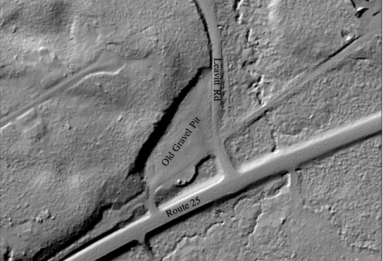
What Newton’s ALS mapping graphically reveals is that the Meena site is situated within a hill of highly permeable coarse sand and gravel that was mined years ago for those materials. When the excavation work was finished, the surface was left with no organic soil and only a thin layer of very permeable, unsaturated material, making it much easier for contaminants to get down to the water table and contaminate the groundwater.
That vulnerability is further brought into perspective by Newton’s discussion of the problems associated with stormwater management, which he calls a “major issue” for all gas stations, regardless of where they’re located.
Water that washes off any paved gas station surface will take contaminants with it to a drainage area, which can create problems. In the Meena case, the danger is obvious, as the site plan for the gas station calls for runoff to be directed to an “infiltration basin” that the State created when it relocated Route 25 and artificially elevated the height of the land for the highway.
The basin, which is in front of the business, downhill from the proposed gas pumps, is, like the rest of the property, comprised of permeable soils. Since the basin has no outlet, any contaminants that enter with the runoff will infiltrate directly into the groundwater.
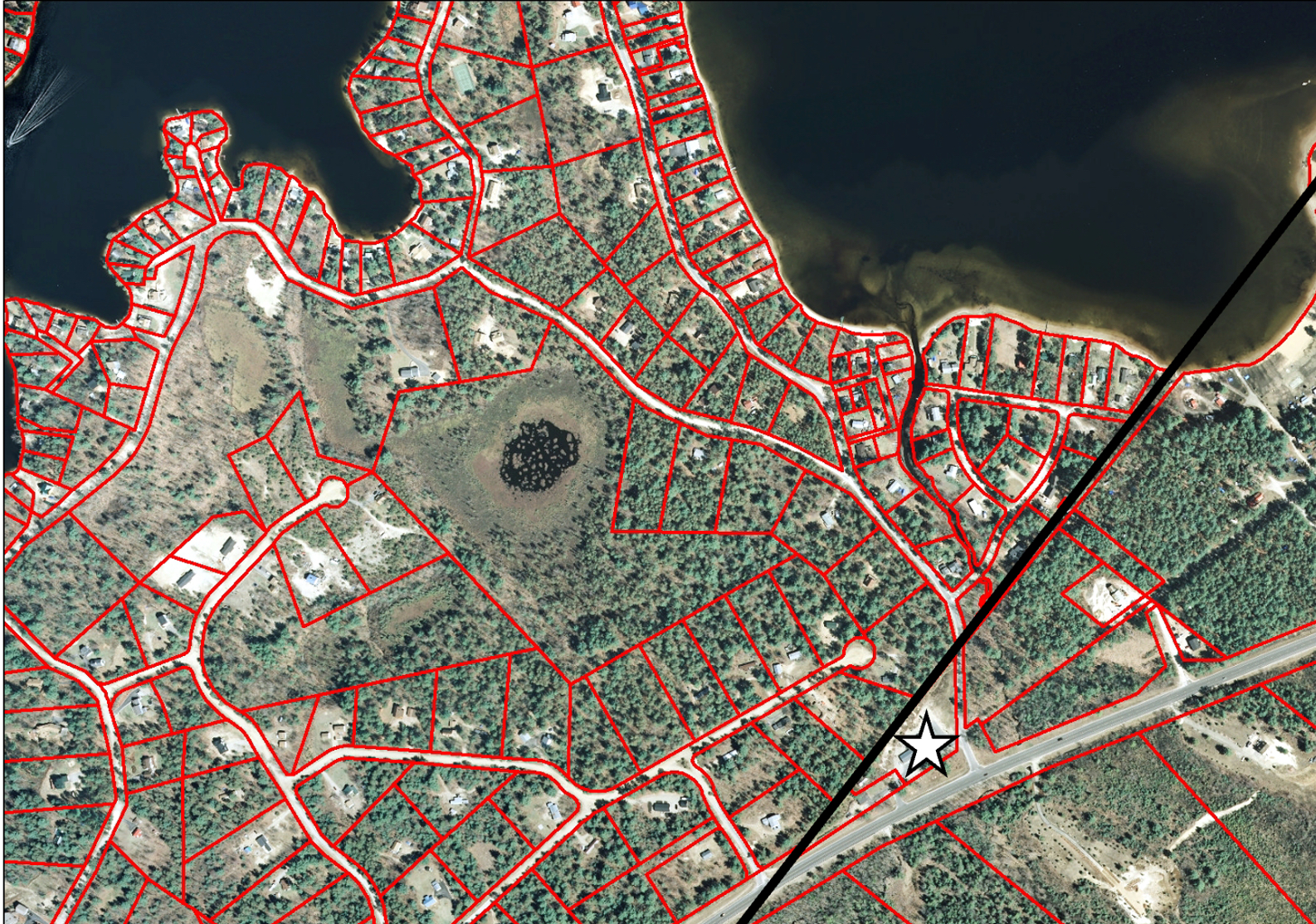
In the video, Newton illustrates the point with aerial photos showing the water table clearly visible at the bottom of the basin. Based on the site plan and rainfall averages, he estimates that more than 800,000 gallons of stormwater would enter the basin annually, and all of it would penetrate directly into the groundwater and threaten dozens of private wells from Blueberry Estates to Leavitt Road, and on to Broad Bay Road, Ridge Road, Remle Road and J Loop.
While Meena’s owner has made much of the fact that the underground gas tanks (which he illegally installed a year ago) are “fail proof,” Newton said there is a much larger environmental danger in runoff that could carry contaminants into the infiltration basin due to spills and accidents, which are routine hazards of the gas station business.
There have been nine spills of more than ten gallons reported to DES in recent years from Carroll County alone, including a 2020 spill in Bartlett that released 45 gallons. Newton also points to a California spill of 1,300 gallons in December that occurred after an SUV backed into a gas pump and the pump’s safety valve failed.
“If an accident like that happened at the Effingham site, 1,300 gallons of gas would enter the infiltration basin and move directly into the groundwater to be discharged toward wells in all directions,” he concluded.
Asked whether such a spill could be mitigated, Newton said an effort could be made that might be partially successful, but it would create new problems, including having to dispose of the contaminated water.
It would also create a set of liability issues, including who would pay for expensive monthly tests to detect contaminants in the drinking water.
At best, however, a mitigation effort would only be a half-measure, he said.
“The only realistic solution would be for affected property owners to find a new source of drinking water.”
Newton said he has sent a letter to the Effingham Planning Board asking for time to present his findings in person once the site plan reviews begin on February 3. Meanwhile, his video presentation is publicly available at this link.
Note: The gas station site plan review is a public meeting, open to all. You may attend in person, at 6:30 p.m. on Thursday, February 3, in Effingham Town Hall, or you may request a Zoom link and participate from home. Send requests for a Zoom link to pb.admin@effinghamnh.net. Zoom requests must be made before 5 p.m. the day before the meeting. Links will be sent out the day of the meeting, per a planning board spokesperson.
Comments (4)
Comments are closed.
One of the main reasons that people desire living in this area is the aquifer and well-water quality. New gas stations, as well as older station tank replacements, must insure against all possibilities when it comes to failures, leaks, and runoff issues. This site appears to have exactly the worst possible soils and runoff solution for a gas station. Accidents DO and WILL happen at some point. We can’t afford to take that chance. There are other gas stations and better sites. Therefore it should not be allowed at the former “Boyles Mobil Station” site.
Just watched the video. This is incredibly disturbing. So Effingham will make the decision and collect the taxes while all the risk (health, financial) affects us residents of Ossipee. Where are our town reps. Where is the state? This is BS
I am not really upset with the proposed gas station on route 25. a gas station was there for a few decades with no problems. I was watching the construction there out of curiosity and was pleased to see that they built the equivalent of a very large swimming pool out of concrete to hold the underground oil tanks so if any of them leaked it would not contaminate the surrounding area. I have no problem with a gas station there.
To take a risk you need to examine the need of doing so.
I see no need, therefore would not take the water contamination risk. It is just that simple.
Jim Tracey – Indian Mound, Center Ossipee NH