
More Lake Level Ups and Downs
Freedom—July 9, 2023—First off, for everyone who has had a difficult time finding the real-time lake level water meter on our website, it’s not your imagination that it’s missing. A change in the way the state posts the data is the reason it was taken down, but more on that later.
The reason people have been looking for it is because the past month’s heavy rain events have caused the water level to yo-yo in a confusing way. The reason is similar to what we wrote about the water level in May, but here’s a recap.
In May, the online chatter was about boats and docks floating free as the lake rose. Good weather in April had people starting summer early, heedless of the fact that the lake almost always floods in April and May as snow melt and rain flow into the big lake from the watershed.
Oldtimers know It’s risky to put boats and docks out before Memorial Day without taking specific precautions so they don’t float away when the water rises—which it almost always does. A lesson learned for newcomers.
Now that it’s July, however, the lake level is supposed to be a constant 407.25′, thanks to Concord’s remote management of the dam. That hasn’t been the case, and, obviously, the heavy rains are the culprit. Less clear is why the water levels are so different around the lake system.
On any given day after a rain event, the big lake may be flooded, while it’s shallower than normal on Berry Bay, and boaters in the cove leading to the dam are hitting boulders they never knew existed.
The reason is simple. Water from the big lake and Danforth Pond flow into Broad Bay, then to Leavitt Bay and Berry Bay and on to the Ossipee River, the lake’s only exit. The channels between the bays act as roadblocks that slow things down.
When Concord opens the dam to relieve property owners in places where the lake level is highest, the areas closest to the dam drain first and fastest.
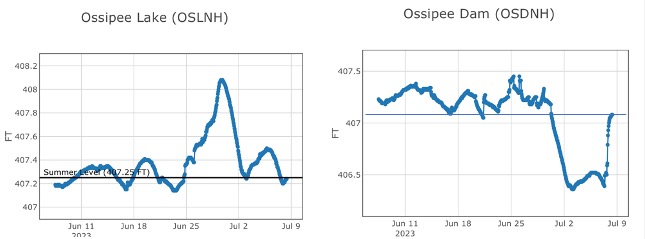
The illustration below shows the water level on the Bearcamp River was 407.4′ on July 2, while the level at the dam on the same day was about a foot lower, 406.6′. That’s the water level disparity people have been wondering about.
After weeks of rainfall in the watershed, the Dam Bureau’s challenge is to limit flooding throughout the lake system while trying to achieve a satisfactory lake elevation that benefits a majority of users.
“This balance is difficult to achieve and varies from storm to storm and will continue to vary with additional rainfall,” Dan Mattaini of DES’s Dam Bureau told Ossipee Lake Alliance in an email.
Mattaini said that the state agency began decreasing discharge from the dam on Friday, July 7, to create a more equal balance between the big lake, the bays and the dam area. The goal, as always, is to achieve a summer level of 407.25′ in all locations—weather permitting.
“Unfortunately, this balance may be interrupted with more rain occurring in the coming week,” Mattaini added.
For many years we captured state water level data and posted it on our website in the form of a real-time chart. It was a popular feature for boaters and property owners, but it stopped working after DES changed the technology it uses to post its data.
We have been unsuccessful in duplicating the chart, but we’re still trying. In the meantime, the state’s information can be accessed at this state website link.
Comments (1)
Comments are closed.
I’m sure this article answers a few questions regarding changes in levels distant and close to the dam. ?