
Visuals Show Westward Shores Is Flooded at Levels Lower Than Previously Thought
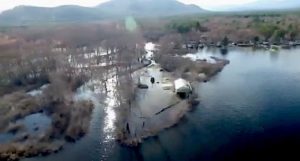
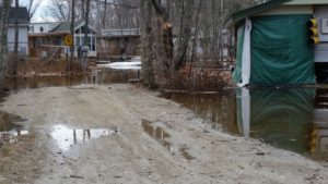
Local residents at the site on Monday found muddy roads and soggy campsites, plus two feet of water covering the narrow access road to the Peninsula, where the business wants to install 15 RV rental units and a new septic system. A drone video taken on Tuesday showed the Peninsula fully covered by lake water and cut off from the main business.
Flooding is a known issue at Westward Shores because it is entirely on the floodplain. But this week’s photos and video validate a long-held belief by lake residents that the campground floods when the lake exceeds 409′ rather than the 410′ figure that appears in survey documents submitted as part of the expansion application. Until this week, only the anecdotal evidence of floating debris from the campground supported the claim that the 410′ benchmark was inaccurate.
On Monday, when still photos were taken in the campground, the lake level was at 409.52 according to the State Dam Bureau. On Tuesday, when the drone video showed the Peninsula still fully submerged and inaccessible, the lake was down to 409.38. The area remained flooded on Wednesday even though the lake had receded to 409.18. The Dam Bureau’s measurement gauge is on the Bearcamp River, next to the campground. The lake’s highest level this month was 409.82 on Friday, April 14. For comparison, the managed summer level is 407.25.
The lake’s tendency to flood has been a key concern of opponents of the campground expansion because of the property’s location adjacent to the aquifer. Opponents fear high water could breach septic systems and gas storage tanks, and dislodge the septic and gas connections to manufactured camper units, many of which are left on the property year-round.
Opponents also say the business lacks a viable flood evacuation plan, citing inadequate escape routes as well as the permanent nature of the camper units. They believe a lack of enforcement of zoning laws combined with the town’s approval of the expansion plan may threaten Ossipee’s flood insurance eligibility under FEMA.
Green Mountain Conservation Group and the towns of Freedom and Effingham are opposed to the expansion as a regional issue, and Freedom has filed suit against Ossipee over the matter.
Westward Shores sparked anger among lake residents last year when its CEO said fears about high water were “overblown” because floods stopped being an issue after the state took over dam management in 1999. The developer later backtracked on the statement after an analysis of state data showed at least 43 occurrences of water higher than the 410′ mark between 2000 and the end of 2015. In some instances, the lake rose more than 5 ft. above the summer benchmark, causing substantial shoreline erosion and property damage.
Historically, the worst floods on the lake have occurred between April and June. But damaging floods have also taken place in October and December, well after the lake was drawn down to its lowest level for the winter.
Note: Ossipee Lake Alliance last year documented the history of Ossipee Lake flooding based on state data. The article may be found at this link. Readers are also encouraged to submit anecdotal information on flooding to info@www.ossipeelake.org.
Comments (3)
Comments are closed.
I’ve been on the lake for 20 years. I have never seen a dangerous flooding incident. The lake fills slowly like a big bathtub. Also, if the EPA would sign off on an additional sluiceway at the dam the lake level could be controlled more quickly.
WWS has zero campers at the park at this time of year even though this article refers to residents are finding a flooded campground….And they are not residents…They are seasonal camping families.
I’m sure in a few weeks the park will be dried out and the summer will be nice for everyone on the lake.
The people documenting the flooding were local lake and town residents. Since much of the site was inaccessible due to the water and mud, we thought it was clear that no campers were present. But we perhaps could have made that point more clear to prevent confusion.
This is exactly why Ol’ Charlie Smith wasn’t buried in a memorial on campground property. His poor corpse would have floated away at least a dozen times since his untimely demise several years ago!