
The Lake Level’s Ups and Downs
Freedom—May 19, 2026—The lake is high—too high measured against the target level for this time of year. Docks have floated away, and there is floating debris everywhere.
We have seen this picture before, but wasn’t the new dam supposed to prevent this kind of thing?
That was the question that some lake property owners have been asking online for days. So here’s the explanation from Dam Bureau Operations and Engineering official Dan Mattaini.
The Ossipee Lake Region has been in a severe drought since last summer. With that in mind, and with no signs of improvement, the Bureau made a decision to keep the lake high early in the season to prevent low water problems during peak season.
Mattaini said the Bureau constantly monitors weather forecasts to see when rain is predicted. When he saw that two inches of rain was on the way, operations were modified to reduce the level.
But the weather forecast was inaccurate. Instead of two inches, the region received at least three inches. Rivers and streams in the surrounding watershed overflowed, and all of that water emptied into Ossipee Lake, Danforth Pond and the bays, headed for the dam.
The current dam went into operation in 2021, replacing a structure that exceeded its expected life and was in danger of collapse. An engineering marvel, the new dam can be controlled remotely from Concord. By all accounts it is an enormous improvement over its predecessor.
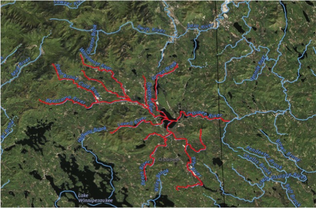
But the new dam did not change the fact that the lake is fed by four major tributaries that themselves are fed by dozens of rivers and streams. Nor did it change the fact that the channels between the bays slow the flow of water to the lake’s only exit, the Ossipee River.
In short, a lot of water can enter the lake in short notice. The more the water, the higher the level as the flow to the dam slows down. The illustration on this page tells the tale.
The illustration also underscores the magnitude of the challenge of operating the dam to manage the water level of the lake on behalf of lake property owners, while also managing the river flow on behalf of river property owners.
In both cases, the Dam Bureau’s goals are the same: to prevent flooding.
The lake’s unofficial flood level was 410′ for many years. That changed in 2017 after Ossipee Lake Alliance matched decades of State water level data against pictures and videos of high water events. It determined that the lake flooded a foot lower, at 409′.
By that unofficial measure the big lake reached flood stage this month at the Bearcamp when it peaked at 409.47. At the dam, the water level peaked just under the benchmark, at 408.47.
For those who lost docks and saw other shoreline items float away, however, whether or not the lake was technically at flood stage was beside the point. It was high enough and higher than they expected. Some lost property or experienced shoreline erosion or both.
Once again we have been reminded that a state of the art dam and the State’s best efforts can only go so far. The geography of the watershed is immutable, Mother Nature always has the upper hand, and the possibility of flooding will always be with us.
You can read more about all this in this article from 2018.
Comments (4)
Comments are closed.
Great report, OLA
From a non engineering standpoint, would it be helpful to place lake level reading devices at or near sources of inflow from rivers which contribute most to lake level?
At the very least, a level monitor accompanied by a water speed reader would warn of pending extremes. And given these measures a formulated plan based on readily available information can contribute to managing lake level.
I’m 4th generation, and my having been on the lake 75+years, I can tell you, we’ve learned not to put our dock or any of the boats out until after Memorial Day. May-June of 1973 there was a flood that brought the level up to our lawn at 414′. I was able to canoe across some front porches, and around and over picnic tables at Westward Shores.
The new dam has made the levels a lot less volatile. But with 4+ inlets and only one outflow, it is a delicate balancing act to maintain a constant level. The state is doing a very good job.
Thanks for the explanation. I understand why all of this happens, and your entry here just conforms that you can neither fool nor second guess Mother Nature.
When the dam max level reading was taken is unknown. On Berry Bay, where the dam is located, the water level reached over 15″ above normal and held at that level for a day. Several area docks were complete submerged. Most passing boats were exceeding headway speed. A stump about two feet in size was deposited at our shore front.